Mrs Sciencebase was on her way home from Seville in Southern Spain yesterday and like any good husband I wanted to make sure she was safe and sound on her travels, best I could do was use one of the flight-tracking websites, among them FlightView, FlightAware, FlightStats, and FlightRadar24. The latter shows pretty much all the same details as the others: Flight number, departure airport and time, and ETA and destination. Aeroplane type, windspeed, altitude, latitude and longitude, weather and various other parameters. But, FlightRadar24 has the best graphs, aircraft positions and an altitude and speed chart.
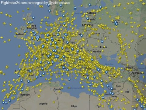
It’s fascinating to watch individual aircraft as well as the bigger picture over a particular country, continent or around the world. And it provided no little amusement for me while she and her friends travelled home, I even live timelined the journey (as opposed to live tweeting it) although it would have been more fun to have been able to send her the occasional message to point out the sites beneath their wings, as it were.
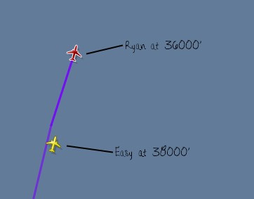
It was interesting to see that within a few moments an EasyJet aeroplane was hot on their RyanAir wingtips, although as it turned out she was heading for London Gatwick rather than (actually, almost in Cambridge) London Stansted Airport. I suggested to Facebook friends that if you’re at all scared of flying, it’s probably best not to have a look at the density of winged metal tubes in the sky at any given time, there are lots and they all seem so close together
I was taking a closer look than that watching Easy chase Ryan up the Spanish mainland, always a couple of thousand feet above and about 5 minutes behind but travelling ever so slightly faster. She was gaining at 38000 feet to Ryan’s 36000. Just as an aside, I pointed out that taking a longhaul as opposed to this shorthaul flight exposes you to the same amount of ionising radiation as if you were to have a standard chest X-ray, the radiation being cosmic (from the Sun and outer space) rather than catching a deliberate dose from the radiographer.
Meanwhile, back on Ryan, it was interesting to see how his bearing was taking him eastward, presumably to take into account the Earth’s rotation and the fact that aircraft fly along an airborne great circle, the planet not being flat. They were on nothing like how the crow would fly between A and B…although the crow maybe would also want to avoid flying over what looks like a massive, avoidable mountain range. At this point, they have covered about a quarter of the “great circle” distance they’re flying (total flight 1680 km, just to mix up the SI and the Imperial units as aviation seems wont to do) and they are heading towards Madrid with Easy still catching them up. I mentioned this elsewhere but last time Mr and Mrs Sciencebase flew together, one of the air stewards told all the smokers in the cabin that they would have to sit on the wing if they fancied a cigarette, hahah, he then gave the weather forecast: -65 degrees and 500 miles-per-hour winds…
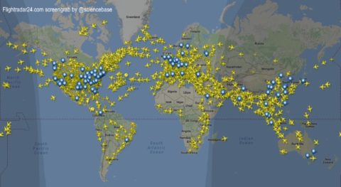
Anyway, serious note: having looked at the density of air traffic over Europe, I thought I’d take pause and have a look at the world too, that’s even more scary and even chewier food for thought given what we’re doing to the world in terms of burning fossil fuels. But the map perhaps also shows how important we consider various parts of the world, some of them massively accessible and connected, others not so much. At the time of stalking Mrs Sciencebase’s flight, the transatlantic air traffic was almost exclusively East to West, this morning everything seems to be heading out of JFK to London, presumably that’s because they avoid night flying, although it did seem odd that no aircraft were making the return trip at all at that time.
By now, Easy had caught up with Ryan but she was still flying at a couple of thousand feet above him and a few miles to the west, but pretty much the same flight path and heading for the north coast of Spain and onward across The Bay of Biscay and western France heading for the South Coast of Great Britain where they’d both reach old Blighty East of the Isle of Wight and cross the interface at Chichester or thereabouts. At this point they began to part company as Easy headed for Gatwick and Ryan ploughed over the clouds to Stansted. I had initially thought they might be heading for the same airport and the inevitable baggage claim clash, but that wasn’t to be, and there were plenty of other jets heading for Stansted meanwhile.
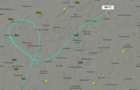
At this point they’re 19 km away from Stansted but still at 14000 feet, I assumed (correctly, as it turned out) that they’d carry on North loop round and descend rapidly to point at the runway at landing speed. They did a loop north of Royston, which is south-ish of Cambridge, but they were 20 minutes ahead of schedule so presumably they weren’t immediately clear to make their landing and so dashed back north east before turning towards Saffron Walden and thence Stansted and the baggage claim…
Just so’s you know, Mrs Sciencebase and her friends are all safely home now and full of tales of sangria, sun and flamenco…